Station Names on Melbourne's Williamstown Line

Hi there!

This post is the second part of a multipart series documenting the origins of the names given to stations that are apart of the Melbourne Metro network. This week's post will cover the fairly quiet Williamstown Line, which will include stations shared with the Werribee line, such as Newport and Yarraville.


But before we get into this week's topic, I just want to mention a few things:

Firstly, thank you so much to everyone who has read the blog in the past few days, my post about the names of Melbourne's City Loop stations seemed to go down pretty well.

Secondly, thank you to everyone who gave me feedback on how to improve this blog. I have added new information about Melbourne's City Loop, which you can read here.

Thirdly, the next part of this series will cover the station's served by the Werribee Line, coming in two weeks. Next week's post will not have anything to do with station names.

Now, with all that all said and done, let us head towards the main topic of this post.

What will be covered in this post?

This post will cover the origins of the stations located on Melbourne's Williamstown Line. This post will also cover stations shared by other rail lines such as Newport, Footscray, and North Melbourne. For consistency purposes, I will also briefly go over Footscray in my posts about the Werribee and Sunbury lines.
Williamstown Line and all its stations. Closed Stations are marked in black because I am colourblind.

With that out of the way, let us dive right in.

North Melbourne

North Melbourne station is geographically located north of the Melbourne Central Business District. Although the station is within West Melbourne, the station may have been located within North Melbourne, with this letter to the editor from the 1860s being evidence for this being the case.

Anything above the black line is above North Melbourne, everything below is West Melbourne.

Some of you may already know this, but for those that do not know, North Melbourne was originally supposed to renamed to West Melbourne as part of the Metro Tunnel project, with North Melbourne being given to what is now known as Arden. This was eventually dropped though, as the new station in North Melbourne is being referred to as Arden.

South Kensington

The station that everyone has heard of but never been to, South Kensington is located within the suburb of Kensington (who would have thought). It is also the southernmost of Kensington's two stations, so that is where the name comes from!
Kensington (top right) and South Kensington (bottom left).

Footscray

Footscray Station was inspired by the suburb of the name. Both the station and the suburb take their names from Foots Cray in England. Foots Cray in England was named after two things. Firstly, it takes its name from Godwin Fot, a landowner from the 11th century. Secondly, the town is located on the River Cray, which is where the other part of the name comes from
Foot stock photo because I do not want to put a map for every image. Gotta diversify, you know?

Footscray used to have two stations right next to each other
, with one station serving the Williamstown Line and was located near Napier Street, and the other served the main line to Bendigo (which used to have the name of Sandhurst) and was located near Nicholson Street. The two stations combined together and became one station in 1900.

Seddon

Seddon is another of a long list of station's named after their suburb. The name comes from New Zealand Prime Minister Richard Seddon (also known as King Dick), who took office from 1893 to 1906. Seddon was fairly significant to the area, being a Corporal in the Williamstown Artillery and an employee of the Newport Workshops (which is every rail foamers dream).

Yarraville

Yarraville is a suburb name that pretty accurately describes the suburb's location, with the suburb being a village (or suburb, take your pick) located on the Yarra River. The name Yarraville was originally the name of a housing estate that was built in the 19th Century.
The suburb of Yarraville that I took from the 2016 quickstats census website. Ignore Kingsville.

At some point in its existance the station was briefly known as 'South Footscray', with the name supposed to be given to what is now known as Yarraville, although there was some backlash towards this change. South Footscray of course, refers to the area being south of Footscray proper.

Spotswood
Spotswood is what you get when you make Spottiswoode easier to spell. The suburb is named after landowner John Stewart Spottiswoode, a man who owned land in the area and also had a daughter who married King Dick. 


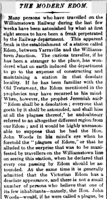
Someone question's the existence of Edom (Spotswood) station in an 1878 edition of The Argus


Spotswood station has undergone numerous name changes throughout its 140+ years of existence. The first of many was Edom, which was the original name given to the Spotswood area. Edom was an ancient land in the Middle East. It then changed in 1881 to 'Bayswater', which reflects the areas proximity to the Yarra River. One month after changing to Bayswater, the station changed its name to 'Spottiswoode', and was then simplified to 'Spotswood' in 1905. A very complicated history for a station best known for Scienceworks.

Newport

Thomas Bent announces Williamstown Junction's name change in an 1881 edition of The Age.

Newport has also gone through a number of name changes throughout its history. Its first two names reflected its role as railway junction, with the station originally being known as 'Geelong Junction' as the original route to Geelong met the Williamstown line at this station. It then became known as 'Williamstown Junction' as this is where the Williamstown line splits off from the main line to Werribee and Geelong. Finally, it became known as 'Newport' in 1881.

There was also a station known as Greenwich that existed in the area, serving as the original terminus for the Geelong Line. Greenwich's name was likely inspired by the town in England.

North Williamstown

Williamstown is the northernmost of Williamstown's three (originally four) railway stations. The station is not quite within the suburb of Williamstown North, although crossing nearby Champion Road will get you into the suburb.
Anything within the weird looking triangle is within Williamstown North. Note that the station is just outside of the cursed shape. Also note 'Wollworths brunswick' which is apparently in Williamstown North.

You might be asking where the name Williamstown comes from, and all I have to say for that is scroll down.

Williamstown Beach

Williamstown Beach station is the closest station to Williamstown Beach. If you want a beach that is within the suburb of Williamstown, then this station is your best bet.

Asking Google Maps how I can get from Williamstown Beach to Williamstown Beach

It had the very creative name of  'Beach' when it first opened in 1889, with many news articles at the time referring to the station as 'The Beach Station'.

Williamstown

Williamstown is named after King William IV and there is not much else to it.

Williamstown Pier

This now closed station was the station closest to the pier located in Williamstown. Williamstown Pier closed in the 1980s due to lack of freight traffic, and is now a carpark.
Williamstown Pier (on the left) as it appeared on Melways edition 1, map 56.

That is it!

That is all for this post! Make sure to comment on how this blog could improve, subscribe by email, and share this post with people who you think would find this interesting! The next part of this series will be in two weeks, and will be looking at the Werribee Line!

Sources

Trove
Victorian Places

Link to other lines in this series can be found here.

Comments

  1. Great post, very interesting! Just noticed that you've got the "location" of the post set to a different Williamstown in the USA, you might want to edit that

    ReplyDelete

Post a Comment

Popular posts from this blog

Station Names on Melbourne's Sunbury Line

Walking from Melbourne to Ballarat